Another nine-mile walk over hills between valleys, this time Cwm Nedd and Cwm Afan. It’s too complex and time-consuming today to take buses, our favoured means of transport, so C and I are reduced to the two-car trick, leaving one at our destination, the Afan Argoed Visitor Centre, and taking the other, via Pontrhydyfen and Neath, to the start at Resolfen.

It’s a perfect walking day, overcast and not too warm, with the odd gentle breeze. Another blessing is the fact that the Memories café is open for a (large, Valleys) coffee and chocolate cake before we set off. We cross the old Vale of Neath railway line, its track still intact, and pass a former chapel, now the community centre. Plaques on its façade commemorate notable locals, including Clifford Darby, a pioneer of historical geography, and the many men who lost their lives in Resolfen’s four coal mines. Almost at once we miss the St Illtud’s Walk sign and go astray: a local woman has to set us on the right path.
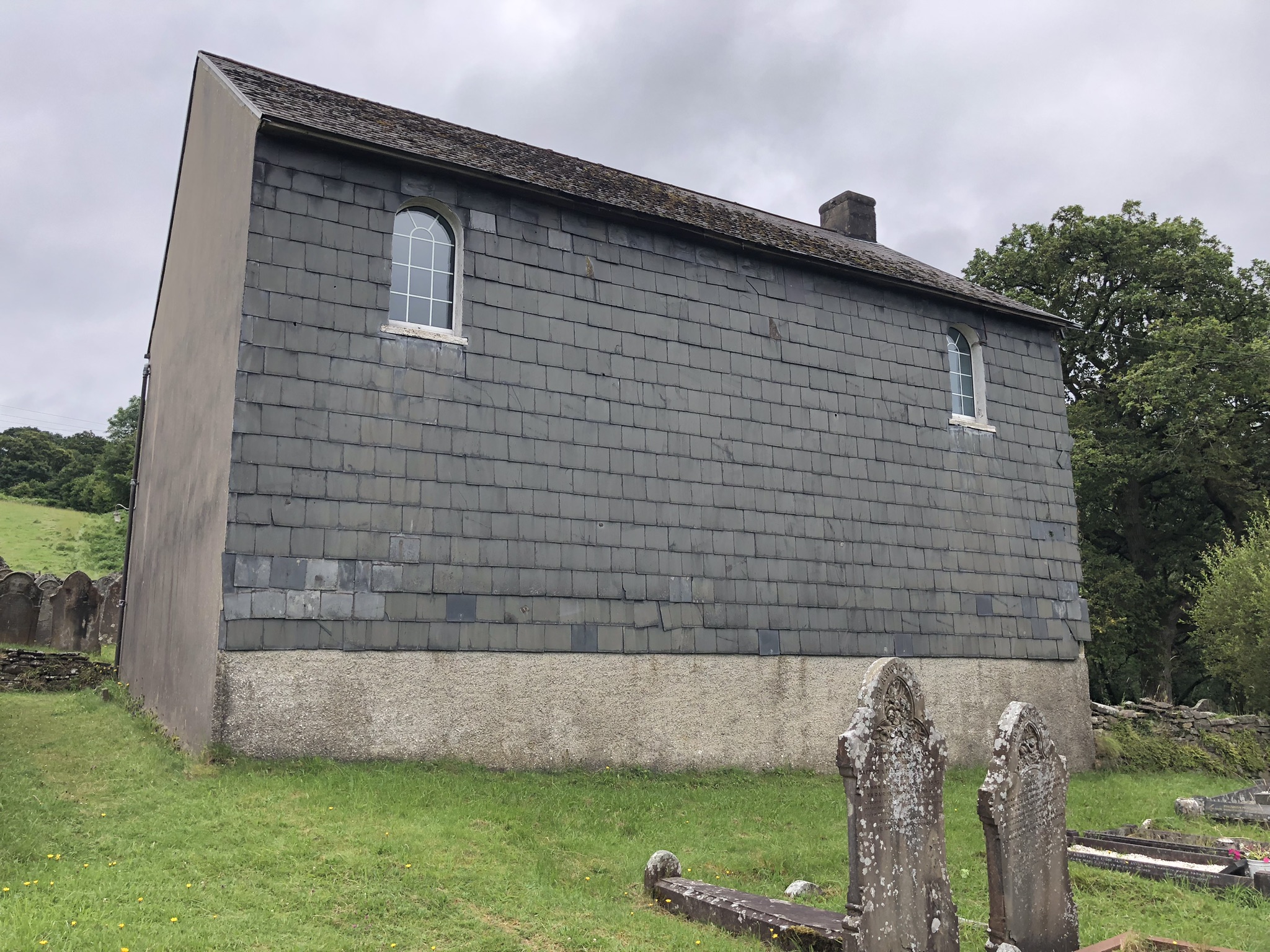
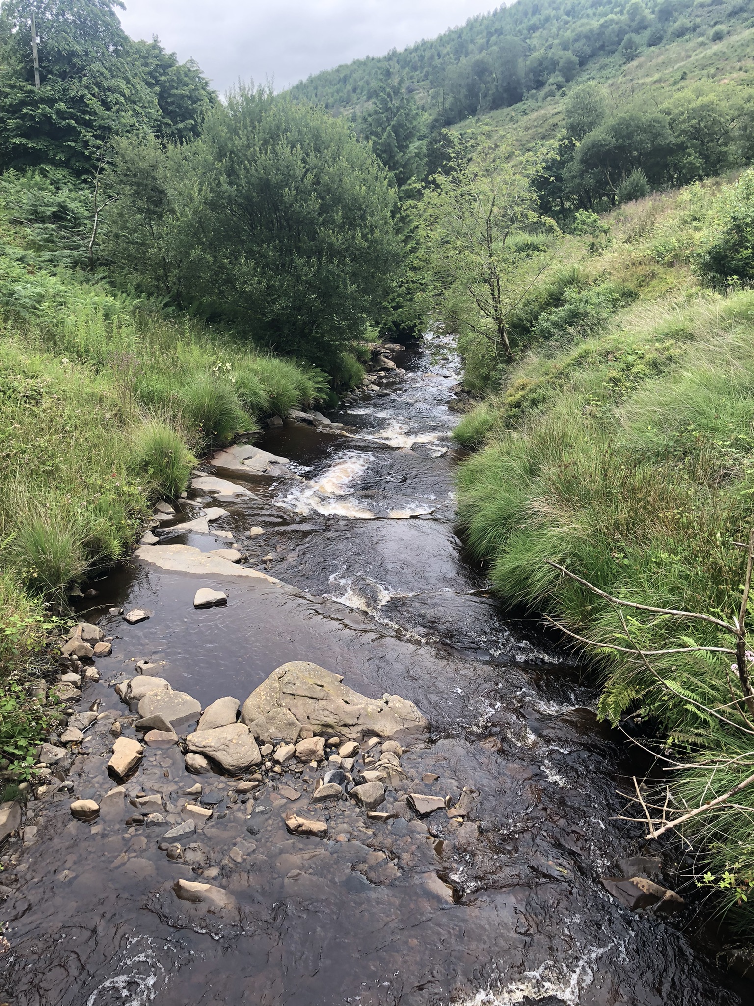
The path takes us through woods, fields and a lane to the head of the waterfall at Melincwrt. We can’t see the falls themselves, but there’s plenty of water eddying in the pools above them: it’s rained during the night. Above the lane is an abandoned Independent chapel, first established in 1799. It’s a back-to-front building. Apart from two small high windows the front is almost completely armoured against the prevailing westerlies by slates, while the entrance and main windows are at the back.

Now we climb, though the gradients are so kind that we don’t feel we’ve struggled much by the time we look back and see a long view back to Resolfen and the Vale of Neath. We pass a woman walking with her dog. She comes, she says, from a local farming family but now lives in Anglesey; she misses the warmth of the people of Cwm Nedd. She tells us that another St Illtud walker is ahead of us. This comes as a surprise, since we’re not met any other St Illtud pilgrims since Pen-bre, over a year ago. The path zig-zags upwards, until we emerge on an upland plateau. Ahead of us are around ten white turbines, moving slowly in the light wind – the first of many windmills on this section of the Walk. A walker is coming towards us across the moor, map dangling from his neck. He turns out to be the ‘pilgrim’, an Englishman recently settled here. He’s exploring local paths rather than following St Illtud. He says he’s turned back, discouraged by finding a locked gate on the path route.

The signposts point us to an recess in the line of the forest line ahead. We reach the Englishman’s locked gate. The OS app’s red arrow, though, tells us not to go through it, but to keep to our side of the forest fence. We struggle over boggy ground to another (open) gate, and into the trees. The going now gets easier. We’re on a forestry track, between old-style ranks of dark conifers. Through another gate, and we’re out in the open again. This seems lonely, remote country, apart from another array of windmills ahead, but it was once full of activity. Cairns point to Bronze Age inhabitants. Somewhere below us in the valley of Nant Melincwrt is a Roman marching camp, though from a distance we can’t make out its boundaries. Nearer to us is the tip from an old coal mine (one of several in this area), and a stone-revetted trackway leading to it.

The path, now invisible, takes us out of the valley up a steep slope. An adult buzzard checks us out, then turns away to wheel lazily around the wind turbines ahead. We stop climbing and turn sharp right, to skirt the western edge of Cefn Mawr, a long, tall ridge or plateau on which sit a row of white windmills (others are embedded in the forest below to our right). From time to time one or other of the turbines lets out an anguished metallic scream, then falls silent again. We wonder if our presence has frightened them. Where the path meets more woodland we find an ideal flat-topped rock to sit on, and eat our lunch. As we munch, we watch the Cefn Mawr windmills and talk of many things, including the installation of windows, the troubles of the Welsh Labour Party and the slow death of the shrinkflationed Tracker Bar.

Back on our feet, we cross a windfarm access road, go through a gate and then find ourselves in a pathless downward slope. We stumble through the reeds, cross a stream with difficulty, twice, and try to trace a way down the steep valley ahead. Eventually we rediscover the path, as advised by the OS app red arrow, but a gate at its entrance beside a wood is locked with a heavy chain. It carries a notice: ‘If you have an issue with access at this barrier’, it says, we should ring a phone number and ‘someone will endeavour to be with you shortly to assist with the issue.’ This advice doesn’t fill us with confidence, and we don’t have time to spare. We climb over and walk on, with a defiant air.

It doesn’t take us long to find we’ve been unwise. The path is certainly the right route, but it’s been disused for so long that it’s become almost impassable without a machete. Head-high bracken flicks in our faces, monster brambles threaten to tear our arms to shreds, and vicious nettles lie in wait. All this undergrowth is soaked from last night’s rain, and soon my long trousers are sopping and all four of our boots are wet inside. Progress is slow as we hack and kick our way through, and the path seems to go on for ever. Finally we stumble through the branches of a fallen tree to reach safety at the end of the jungle, and find ourselves on a footbridge over Nant Cregan.

After that, Cwm Cregan is an easy descent, past old mine workings, along a tarmacked track that nature has almost swallowed. At the bottom is Abercregan. When the mines were working this was a thriving village, with a chapel, school and rugby team. Now all three and most of the people have gone, and only a few fragments of terraced housing remain. C notices that though the school has vanished its railings survive. On a noticeboard are pinned poignant photos of that other age.

Now we’ve reached the track of the old South Wales Mineral Railway, which will take us all the way from here to Afon Argoed. It was built in stages between 1861 and 1863 to connect the coalmines of Glyncorrwg and other Cwm Afan villages with Briton Ferry. The engineer was Isambard Kingdom Brunel, and as we walk along we can only admire the way Brunel and his workers created the wide-gauge railway, using a cut-and fill technique, high on the super-steep hillside. An elderly man on an e-bike stops to talk. Like us, he’s on his way to Afan Argoed. He means to return via the cycle track, once the route of the other Afan railway, on the east side of the river, calling in at Cymer for a library book on the way.

We continue, grateful for the level gradient and the views across the river below to the woods and hills beyond. Apart from the sound of Afon Afan, and some roadworks at one point, it’s a quiet scene. On both sides of the track pink-flowered Indian balsam run riot. As C often says, there’s nowhere else in Wales that comes close to looking like miniature Alpine scenery – though the Alps lack the spoil heaps above Duffryn Rhondda. Finally our red arrow shows a path down to the river. We have to stand aside as three young trail riders flash past. At the bottom a sign, too late for us, bars pedestrians from the path on the grounds that it’s reserved for bikers (this area is prime mountain bike territory) . We cross over the wooden bridge and climb back up to the Visitor Centre. Our last act, before retrieving the other car from Resolfen, is to visit the café and eat two Magnums, a fair reward for a strenuous day’s walk.

Leave a Reply