
It’s early on Saturday morning. Friday night has exhausted the inhabitants and the streets of Llanidloes are quiet as the four of us set out across the town. The Red Lion in Long Bridge Street is clearly a royalist stronghold, parading its union flags and coronation kitsch. On the other side of the street the Elephant shows nothing but Welsh pennants: are the owners making a point? It’s cloudy and hazy, but the sun won’t be long in appearing, as we cross the Severn and move off the road on a woodland path. The wood is Allt Goch, its trees happily transformed from conifers to broadleafs by the town council. We climb up, until we see a sign warning us of stray golf balls. But the wood continues, until finally we reach the St Idloes Golf Club. At the entrance to another wood several fierce signs promise that our non-existent dogs will certainly be shot if they worry sheep. Next we pass through fields. C1 releases a crow whose claw is entangled in a fence, but it seems injured and unable to fly away. We’re now high above Llanidloes with views over the town.

We pass a farm building, painted black, white and red, as if a Dutch De Stijl artist had passed by. Soon we can see the village of Van in the distance. Van was an old lead-mining centre, and two chimneys still stand behind it. An industrial terrace once housed the workers. They had a choice of two chapels, presumably the one they attended and the other they didn’t. At the entrance to a field we find two large pieces of old, rusted agricultural equipment, a reaper and a roller. They’re placed there as if they were exhibits in a museum. We examine carefully their tines, rollers, teeth, handles and wheels. It almost seems that with some attention they could be made to work again, decades after they were abandoned.
We pass Bryntail Cottage, now a ruin, but from 1915 a rural base for schoolchildren from Birmingham. A charity is trying to raise money to restore it to similar use in future. We decide to take a break, taking care to avoid the worst of the sheep droppings. We see the same two men walking Glyndŵr’s Way ‘backwards’ whom we saw yesterday. From where we sit we can already see a pile of waste from the lead mines at Bryntail, and when we start out again the track leads us on a long trail down to the remains of the mines at the foot of the Clywedog dam.

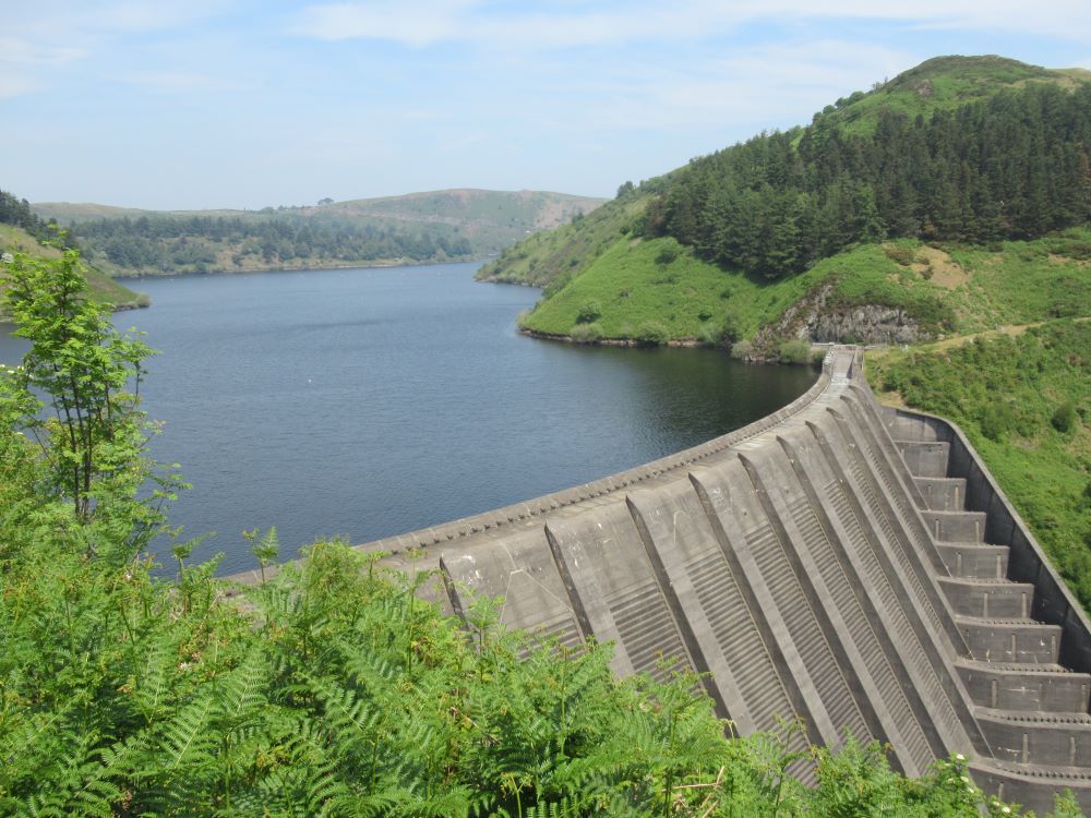
We stop several times to photograph the huge dam wall, and debate whether it’s a good or a bad example of sixties Brutalism. Nine long, flat ‘pilasters’ buttress the face of the dam, and a fan of steps at the left side provides a cascade for overflowing water. In contrast, the wooded gorge we’re passing through is a riot of rich greens. It’s a curious experience, standing among the industrial ruins in the shadow of the dam: a strange mixture of Machu Picchu and a Sumerian temple. It was here, a few years ago, that I met my first Glyndŵr’s Way walker, who was travelling alone and carrying his own tent.

It takes an age to cross the Clywedog, a rapid spate, and climb back up to the level of the reservoir, on the other side of the dam. Since it’s the only real café open during the day on any of our six days of walking, we feel bound to call in at Caffi Clywedog for some coffees. A. has a prolonged conversation with the woman serving about the exact meaning of ‘double Americano’, and ends up with two shots of coffee and his own teapot full of boiling water. We start again, and follow the path as it winds its way, with several gratuitous hills, along the various fingers of the six-mile-long reservoir. Where the path passes the Clywedog Sailing Club a sign announces ‘Danger: Drop’, translated into Welsh as ‘Diferyn Peryglus’.
Somehow this landscape encourages conversation on all kinds of subjects, large and small: what a ‘dangerous drop’ would taste like, the nature of memory (and false memory), Swallows and Amazons and the theme of absent parents in children’s books, milk intolerance and breakfast cereals.

Our lunch stop has a view of the reservoir. The air’s still and warm, and voices of people in boats far below carry up to us. On the other side of the water the rounded hill called Dinas, topped by a hillfort, rises high. We’re sitting on a steep slope, too, and a dropped apple would quickly roll down and out of reach.

After the break we escape at last the tendrils of Llyn Clywedog and move up to and through a wood. Further on, two Spanish trail runners catch us up and we exchange a few words. Unfortunately, they’ve followed us into a trap. We’ve missed a sign and we’re on the wrong side of a barbed wire fence. We’d need to retreat a long way to correct the error. Lower down the slope, the runners have realised the problem. They climb and leap over the wire like hares and soon disappear into the distance. Our stiff and ageing limbs find the same manoeuvre a bit harder, and the barbed wire cuts a neat hole in C2’s brand new Rohan trousers.
There’s more woodland ahead. Actually, we’re in the extreme north-eastern edge of the Hafren Forest, where we ended the Wye Valley Walk last year. Far from being a dark and gloomy forest, it’s airy and full of birdsong. We emerge at the top and find a bird hide, for observing the two ospreys that have nested close to the reservoir below. In the hide’s daybook we can see that there’ve been several binocular sightings today: ‘8:50 Grey and cool. Seren on nest, no sign of Dylan; 12:50 Osprey on the nest. 2d osprey arrived too with fish’.

A flatter, more pastoral section leads to more uphill work. A ‘featherman’ has been here, placing a single feather on each gatepost, an obscure ritual we noted from Offa’s Dyke. We move through a steep and deep holloway, then across a large field on to open moorland. Now we’re often walking on raw bedrock, a sign that the soil here is thin as well as poor.
The Way carries on at this high level, but eventually Dylife comes into view far below on our right. ‘Dylife’ makes it sound like a village (it had a population of 1,000 in the 1860s), but the few buildings left there are dominated by the piles of waste extracted from the nineteenth century lead mines, the only reason for human habitation in this bleak spot. A few drops of rain start to fall. Could this be the beginning of the thunderstorm that the weather forecasters have been threatening us with for days? We leave the Way and hurry down the long track to Y Star, a former droving inn, where A. is due to stay the night and where the rest of us are to be picked up. We spot a rare sign for the Cambrian Way (one of the few Welsh routes we’d be reluctant to tackle). A. generously unpacks from his car some amazingly cold drinks for us to gulp. Our lift arrives, and we’re taken town the valley to the village of Pennant for a meal and a bed. Rain comes, preventing an evening stroll. Instead, the three of us sit in the conservatory and have a long and passionate debate about the doubtful intentions of an incoming Labour government, and the perennial opposition of liberals and socialists.

Leave a Reply