The excellent X13 bus runs all the way from Swansea to Llandeilo, but today C. and I take it just as far as Pontarddulais. We aim to climb Graig Fawr and explore the hills beyond, as far as Penlle’r Castell, and maybe beyond. The Met Office promises a cloudy but rainless day; it’s warm enough, but autumn’s in the air. We start, as all good walkers should, with coffee and cakes, in Sullivan’s café in St Teilo Street (there, we’ve already collected two saints). The street still has plenty of small independent shops, including Aubrey’s (‘footwear specialist’), with its fine symmetrical façade.

We amble through the streets and the suburbs to the north-eastern outskirts of the town. Beyond the gate at the end of the last, narrow road a posse of sheep form a welcoming party for us. It’s a very gradual climb up Graig Fawr, along a broad green path bordered by thick bracken. We agree that the bracken should still be green instead of the rusty colour it is. Presumably the drought in May and June is to blame for its premature ageing. To our right is the valley of the Camffrwd and beyond it the parallel ridge of Cefn Drwm (which makes a satisfying round trip if you need to return to Pontarddulais). As we rise, the winding waters of the Loughor estuary and the north coast of the Gower peninsular start to appear on the southern horizon.

We keep an eye out for two Neolithic tombs, of the Cotswold-Severn-type, close to the path. In two previous trips along this path I’ve not been able to find them, and we fail again today: I suspect you need to come in winter, when the bracken has died down. Further on and higher still, the Loughor valley and the fields beyond it come into sight, and after a final short steep climb we’re on the hilltop, with near-panoramic views for miles around, from Whiteford Point to Llandybïe and the Black Mountain, and south to Port Talbot.

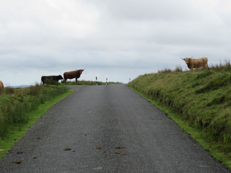
Suddenly we’re in the high windmill land of Mynydd y Gwair. None of the turbines is working today. We can’t help noticing that the tops of the vanes are becoming lost in low cloud. Bad weather is beginning to roll in from the south-west. Soon it’s drizzling, contrary to Met Office advice, and we need our jackets. The going’s easy, along the flattish ridge, until we reach the narrow road at Pen-y-Cwar. Here there’s another reception committee. The road’s guarded on either side by a group of long-horned cattle. They look as if they want to check our passports, and we hesitate. At that moment a farmer in a car stops and tells us not to fear: they’re harmless Scottish cross-breeds.

We pass a sub-station connected to the windfarm and its pylons, noting the danger of sudden death, and then miss the right path. Instead, we’re on the windfarm track, which runs parallel to the path and passes several of the mills, one of them very close. By now the drizzle has graduated to driving rain, and the waterproof trousers come out of the bag again. Even in good weather the towers make eerie travelling companions, but today they’re stranger still, their upper parts and sails lost in cloud. Even the stoical St Illtud, we feel, would have felt a bit dejected in the mist and rain. His woollen cloak and hood would be impossibly sodden and heavy by now, you suspect. Every so often we pass a sign marked ‘Exit’, which has a sinister finality about it (the exit, of course, is lost in the mist).

The path we should have been on joins our track above woodland. We rejoin it to follow the contour above a steep ridge to reach Penlle’r Castell, far earlier than we’d expected, partly because we’ve had no stops, and partly because the advertised 8.5 miles overestimates the distance of this section of St Illtud’s Walk. Across the road and another short stretch of tussocky ground we find the mound, ditch and rampart of the Norman castle. It’s thought that it may have been built in the mid-thirteenth century by the brutish baron William de Breos, to guard the northern frontier of his new lordship. We sit in the ditch on the lee side of the mound, munch our sandwiches and sympathise with the poor Norman privates who drew the short straw of garrison duty in this bleak place, far from creature comforts and open to sudden attack by the rebellious Welsh of Is-Cennen to the north. It’s hard to think that technically we’re still (just) within the boundaries of Swansea.

It’s stopped raining by this time, and we wonder what to do next. We’ve an offer of a car lift home, but decide instead to carry on walking down to Ammanford across Mynydd y Betws, past another wind farm (I did this walk, in reverse, in 2019). These turbines are working, each sending out a soft-but-loud swish as their blades slowly turn. We pass another sub-station, complete with handy map of all the turbines, and the Scotch Pine, once a pub. Then we begin the long, often steep descent to Betws and Ammanford along the Colonel’s Road. You’d hardly guess now that Betws was a mining village, with a pit that finally closed only in 2003. Opposite the site of the pit is a large park, with a signpost pointing in one direction to Y Byd and the other to Betws! Across the river and the railway line we’re in Ammanford, and wait with another coffee to catch the X13 back to Swansea.


Leave a Reply