In 1939, just before the outbreak of war, a woman called Hope Hewett published a book about her journeys alone on foot around Merioneth. She has a genial and charming authorial voice, recounting her travels in the company of Jack, her faithful terrier, as they criss-cross their way across the county. Today Hope and her book, Walking through Merioneth, are all but forgotten, but in the last few days I’ve been paying tribute to her by walking a few of my own routes in upland Meirionnydd.

My base was Dolgun Uchaf, just east of Dolgellau. I’ve stayed there twice before. It’s well-placed for Cadair Idris and it’s a handsome, historic house, built around 1500. Peter Smith, the authority on vernacular houses, thought it one of the best examples of a late-medieval hall-house in Wales. In the seventeenth century it was owned by a family of Quakers, who formed a strong community around Dolgellau, until they were scattered by the persecutions after Charles II was restored to the throne.

On the first day, I went to the western side of Cadair Idris to follow the first stage of the Mary Jones Walk. In the later nineteenth century Mary Jones became famous all over the (Christian) world, for an act of extreme piety. In 1800, aged just fifteen, she walked barefoot from her home in Llanfihangel-y-Pennant, at the head of the Dysynni valley, to Bala, a distance of nearly thirty miles, to acquire a bible from the famous preacher Thomas Charles. Her parents were very poor and there was no bible at home: she had to go to a neighbour’s house to read one. (This reminds me, absurdly, of having to go to our neighbour’s house to watch television when we were young in Hoylandswaine, since we had no TV – by parental choice, I should add, rather than through penury). A few years later, inspired by Mary’s heroism and devotion, Charles and others founded the influential British and Foreign Bible Society. It wasn’t till decades later that the story, transmitted orally, was finally published, with a great deal of embroidery and myth-making, much of it generated by the Bible Society.

I started out from the church of St Michael, close to Llywelyn Fawr’s Castell y Bere, the least advertised and least visited of the great castles of Wales. It’s a simple church, with a so-called ‘leper’s window’, set at an angle to give an external view into the chancel, and a brass plaque bearing the words ‘Cofiwch y tlawd’ (remember the poor). Mary Jones’s parents were buried in the churchyard. Both were early Methodists, who would, had they lived slightly later, have turned their back on Anglicanism.

Opposite the old lychgate of the church a path led south, up through old oaks and alongside a stream. It had just started to rain, and though the rain ceased, low clouds hid the mountain tops all afternoon. After the climb the path opened out as a green track into a broad, boggy cwm with hills on both sides. I was on my own, with only a few high ravens for company. The aftermath of the recent heatwave made for sweaty progress. Towards the head of the valley were the ruins of Nant-yr-Eira, from which it takes its name. Red-berried rowans grow inside its collapsed walls.

I ate a sandwich by an old field wall. At one time Meirionnydd must have employed a small army of masons to build the miles of drystone walls for which it’s rightly famous. Here in the uplands, and in particular across the Mawddach in Ardudwy, many of these walls, still standing intact, cut dead straight lines across the landscape for hundreds of yards, ignoring changes in height. Sometimes they incorporate huge boulders, which must have been a pain to transport. Over the watershed, I walked gently downward on a forest track through Coed Cedris, almost to the main road, before rising again through Coed Maes-y-pandy to the farm of Rhiwogof, above the southern end of Llyn Mwyngil (Tal-y-Llyn Lake). Across the lake rose steep slopes, their tops covered in cloud.

My plan was to make a circuit by turning east down Cwm Nant Pencoed. The easy broad track I started on came to an abrupt halt, and it wasn’t easy to find a path above the boggy centre of the valley. As I climbed towards the old farm of Pencoed the path disappeared altogether, and I found myself thrashing through waist-high bracken, soaked by the recent rain. Below me a tractor was crushing the bracken in an attempt to control its growth. At last I found a way off the mountain and down into the valley of Afon Cadair. A track and then a lane took me past Mary Jones’s house, Tyn-y-ddôl, and back to the church.

On her trip Mary wouldn’t have climbed up to Rhiwogof. She would have walked on the flat, alongside Llyn Mwyngil and then up the gentle slope of Cwmrhwyddfor, the pass that skirts the south cliffs of Cadair Idris, on her way to Bala. It’s a long journey, but not a specially difficult one, even barefoot. To the respectable late Victorians, who had reduced their women to domestic inaction, Mary Jones’s walk appeared astonishing and heroic. But in the late eighteenth century many Welsh women walked long distances unnoticed, and they often walked barefoot, again unnoticed except by visiting English tourists.
The next day was given over to Cadair Idris. My series of annual pilgrimages there had been broken by Covid, and I’d missed several years. The weather forecast on the previous day had been for continuous sun from dawn to dusk. But it was not to be. During the night a north wind blew in, bringing sheets of cloud and the threat of rain. The mountain tops were invisible. I decided to carry on, in the hope that the cloud might lift.

My first idea was to climb by the Minffordd Path, strenuous but always my favourite route. But as I drove along the main road from Cross Foxes another idea came into my head, and I turned the car into the layby at the top of Cwmrhwyddfor. It was almost empty, so early on this unpromising day. There’s a path up Cadair from here. I knew little about it, except that it’s not included in the standard lists of regular ascents. Only the lower slopes were not in cloud, but I started out.
The path takes a gentle, oblique line up the introductory hill, Mynydd Gwerngraig. There were several people on it, some in a group, but I walked past them and upwards, and soon I was entirely on my own. The path was clear, but it led to the foot of a steep, rocky section that guarded the plateau beyond and the eastern summit of Cadair, Gau Graig. It was a tough scramble, and called for the use of both hands as well as steady feet.

At the top I stopped by a stile in the fence. Suddenly figures loomed out of the mist: two young men in a bedraggled state. They said they were lost and asked which was the best way to get off the mountain. Like me, they’d been deceived by the previous day’s weather forecast, and had set off up Cadair at three o’clock in the morning with the intention of seeing the sun rise at the summit. Instead, the day began dark, and they were adrift in the clouds. I told them the good news, that they were near the road, but warned them to take the utmost care in following the path down.

I followed the path westwards along the broad back of Cadair Idris towards the summit of Mynydd Moel, without the spectacular views to the north that better weather would have given me. I met only two other people, one a runner from Aberdeen, who planned to follow up this trail with a traverse of the Horseshoe on Yr Wyddfa. After a short break at the shelter on top of Mynydd Moel I felt two or three minutes of complete disorientation in the fog, an experience that can frighten you, even if you have map, compass and the Ordnance Survey app. Soon, though, I re-found the path and walked on to Pen-y-gadair and then beyond, towards Craig Cau, now free of cloud. There I had a conversation with a young German couple, who were wondering whether it was worth carrying on to the summit, still invisible (they decided against). The rain now began in earnest, and some people I met as I came down the steps to Minffordd, including the parents of two rucksack’d babies, thought better of continuing, and turned round.

The café at Minffordd was closed. I had no choice but to trudge on up the grassy track of the original road up Cwmrhwyddfor, back to the top car park. I passed a field of white bags, each filled with rocks, waiting for a helicopter to hoist them up the mountain for path restoration. The cliffs of Cadair glared down on me to my left. It had been a frustrating but exhilarating day.

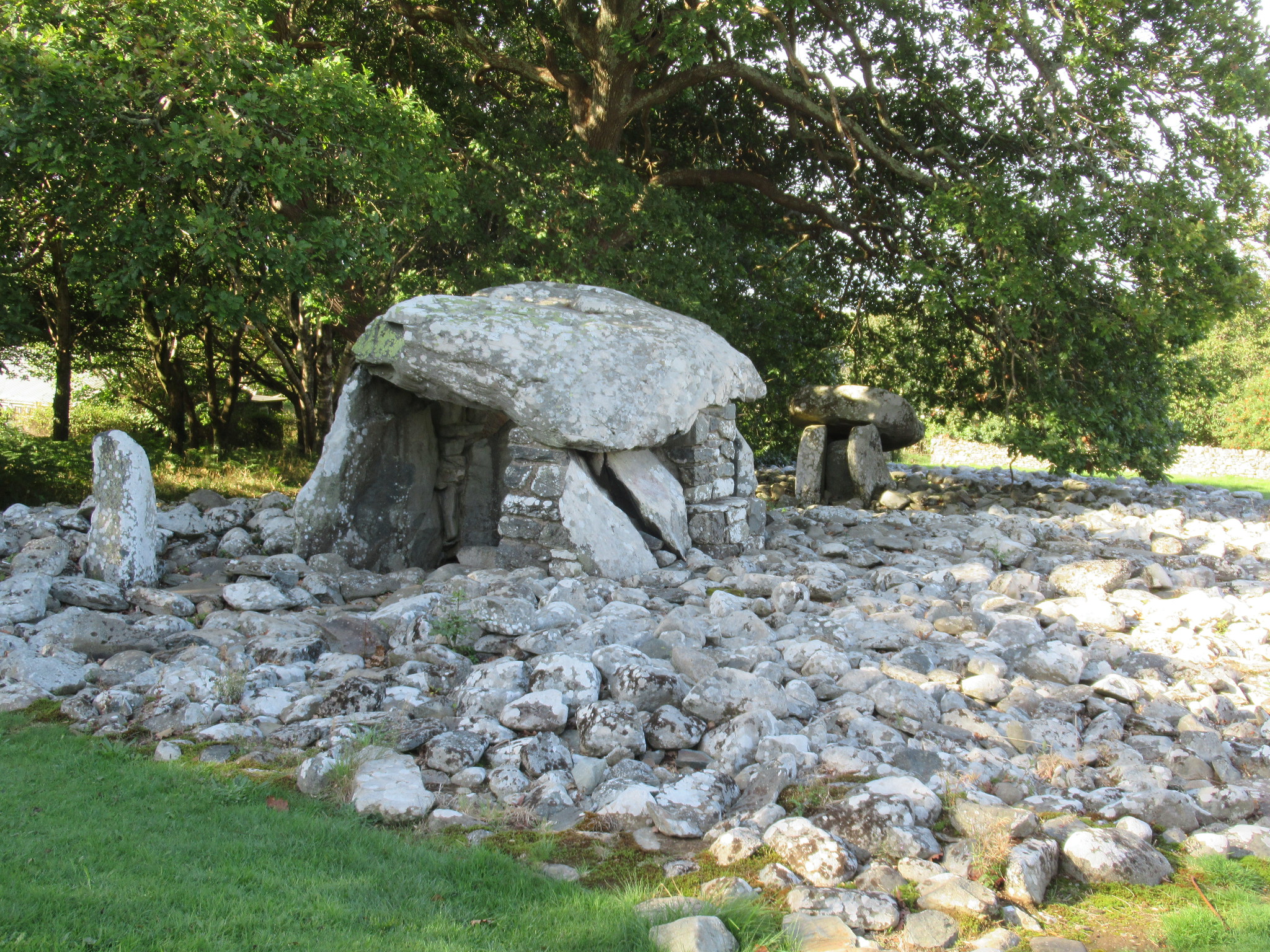
On the third, much brighter day I crossed the Mawddach to explore part of Ardudwy. Leaving the car at Bontddu I caught the Lloyd Motors bus, through Barmouth, where the bridge was closed for repairs, and got out at Dyffryn Ardudwy. Almost as soon as I left the coast road I went astray while trying to find the village’s famous Bronze Age chambered tombs. After blundering my way through several fields I suddenly spotted, across a tall stone wall, the giant capstone of one of the tombs. The monument – in the end the two tombs were covered by a single enormous pile of stones – has a fine view across the sea, as its builders presumably intended.

A path led from the burial chambers to Ffordd Gors, a long lane that ascends from the village in a dead straight line up to the mansion of Cors-y-gedol, old home of the powerful Vaughan family. They were noted patrons of Welsh poets, and collectors of manuscripts. They were also good eaters. Richard Vaughan, elected MP for Merioneth in 1628, was so obese that the large doors of the House of Commons, normally opened only by Black Rod for ceremonial purposes, had to be flung open to let him in. Beyond a grand gate, the straight lane, now private, marched on towards the house, while a public side-lane wound obsequiously around the perimeter of the gardens. Across the walls I could see estate farms and a rustic cottage.

A strange thing then happened. Almost as soon as I left Cors-y-gedol I found myself in a completely different landscape: wide open, mountainous and deserted. I was on one of the old drover’s roads. It was around ten yards wide and enclosed by tall stone walls. The track strode out boldly across the huge brown-green plain lying between Moelfre, the bulbous hill to the left, and the long range of hills on the right – part of the chain of mountains that stretches from Trawsfynydd to Barmouth and includes Rhinog Fawr and Rhinog Fach.

I was making for the famous cobbled, single-span bridge called Pont Scethin. Built in the eighteenth century, it crosses Afon Ysgethin and sits in lonely isolation in the centre of the plain. No other human structure can be seen, for miles around. I wanted to take some photographs of the bridge. Just as I was giving up hope that there might be one or two other people I could catch on the bridge for inclusion in the photos – I’d seen no one at all since leaving Cors-y-Gedol – I overtook three people, a woman and her parents from Llanfairfechan, who were going in the same direction. I fell in with them, we chatted in Welsh, and they agreed to pose for me on Pont Sgethin.
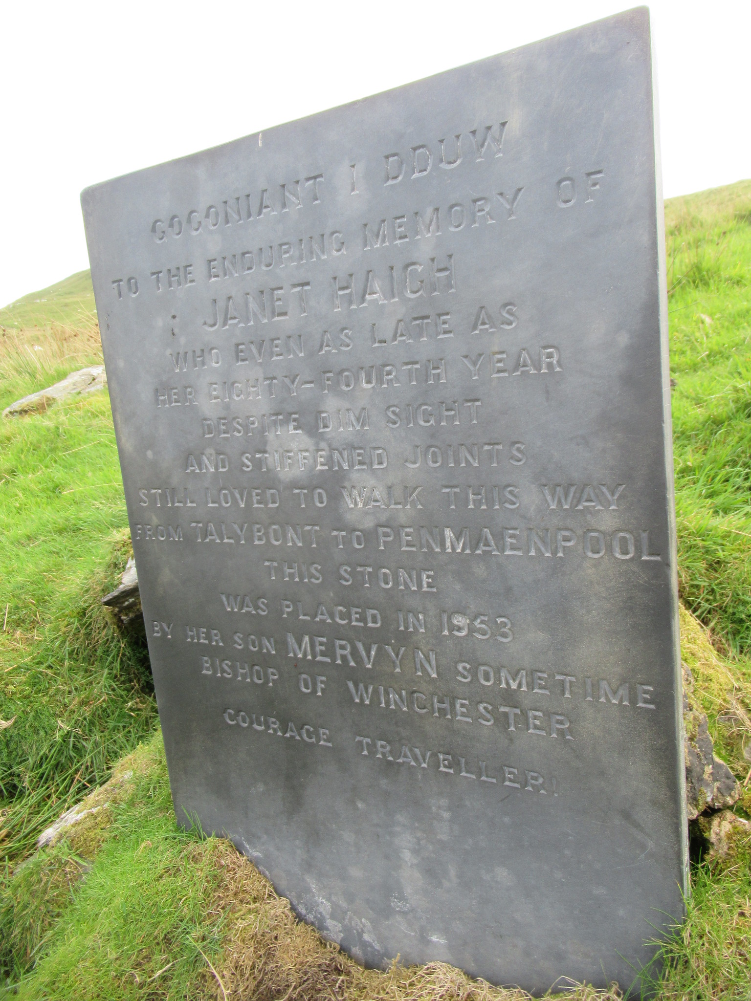
They also gave me directions for following the drovers’ road onward. The track led slowly up the flank of the hill called Llawllech. At the point where it turned at a hairpin bend to climb again in the opposite direction, a slate memorial stood. Mervyn Haigh, Bishop of Winchester, set it up in 1953 to commemorate his mother, Janet Haigh. The inscription explains that Janet followed this route every day, even in her mid-eighties, on her journey from Tal-y-bont to Penmaenpool, a distance of over ten miles (in those days she would have been able to take a train home). The climb was long, and I wondered how hard it was for the drovers to encourage their cattle to the top of the pass. As I neared the summit I could see two men lounging by a gate, where the Cambrian Way crossed the drover’s road. One of them was drawing on a cigarette. Beside them were two motor bikes with the kind of tyres that do so much damage to upland tracks in Wales. I was ready to look disapprovingly at them when the man with the fag disarmed me completely by smiling and opening the gate to let me through. We wished each other well.

Through the gate, an immense scene opened up to the south. It was like opening your eyes to an epic film in an IMAX cinema. The vast northern screen of Cadair Idris lay straight ahead, dark and shadowed. Below it to the right, the estuary of the Mawddach, by now half water, half mud, flashing and gleaming. To the left, the slopes of Diffwys, and below me, a gentle bowl of moorland, scored by intersecting stone walls. I stopped to eat my lunch and marvel.

The drover’s road now made a slow descent along Y Braich, an arm of Diffwys, the north face of Cadair always visible ahead. Towards the end, the junction with a tributary path to Tal-y-bont was marked by a big old milestone. Then the track turned into a quiet tarmacked lane that moved south alongside Afon Cwm-llechen, all the way down past Llechfraith to Bontddu – a quiet coda to what must be one of the finest short walks in Wales.

Next door to Bontddu is the hamlet of Caerdeon, and I finished my three days by seeking out its church, perfectly hidden at the top of an obscure lane off the main road. St Phillip’s, now looked after by the Friends of Friendless Churches, has a strange origin. It was built in 1862, as the result of an argument about the use of the Welsh language in Anglican services. Its architect, J.L. Petit, designed a strange, unGothic, proto-modernist building, with rubble-slate walls, belltower-cum-chimney, a loggia instead of porch, and some striking stained glass. The churchyard slopes away in an elegant bowl to the south. It’s a tranquil place, and it made a still end to three days of constant motion.

Leave a Reply